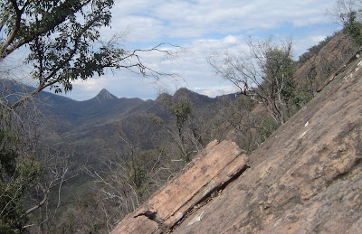
Mount Sugarloaf, Cathedral Ranges
A sugarloaf is a cone of sugar and is how sugar was sold before sugar cubes were invented. The pointy shape of many mountains has led to them being named Sugarloaf or Mount Sugarloaf or Sugarloaf Peak or some variation on that theme. According to Wikipedia there are over 400 Sugarloafs in Australia. The Sugarloaf in this story is in the Cathedral Ranges in north-east Victoria, not far from Marysville.
 |
| Mt Sugarloaf (the pointy one to the left) from the other end of the Cathedral Ranges. |
This Mount Sugarloaf is a pointy, rocky peak of sandstone at the southern end of the Cathedral Ranges. Along with numerous routes requiring ropes and climbing gear, there are two walking tracks to the summit. One is known as The Canyon for a small, canyon-like feature you have to crawl up, and the other is Wells Cave, named after a cave you must squeeze through. The Canyon is regarded as a hard walk and I have known a few people to struggle because of their fear of heights, particularly above The Canyon section. The Wells Cave track is even more difficult and more exposed to gravity vibes.
The Wells Cave track starts off a foot track climbing steadily through forest regenerating after the Black Saturday fires of 2009 to the base of the rocky upper slopes. The first bits of rock to be encountered aren’t too bad but then things tack a turn to the vertical (actually, not quite vertical, about sixty degrees) requiring some hands and feet style bushwalking to get to the base of the main cliff. From here rock climbers will unpack their ropes and harnesses and continue straight up – hikers head north along the base of the cliff towards the cave.
 |
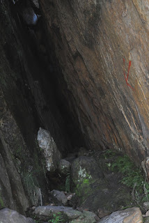
| The entrance to Wells Cave. |
Not so much a cave but a crevice, gap thing formed by a large slab of sandstone leaning against the main cliff. Looking into the cave, the other end is not visible – just darkness. A red arrow painted on one wall however indicates that this is the way to go.
As you get deeper into the cave it gets darker, damper and narrower. The final moves see most people turning sideways. Packs definitely need to be removed and passed through.
After emerging from the cave there is one last climb to the top. While I have done this walk a number of times I always seem to get stuck here – not sure where my feet are meant to go and desperately looking for something to grab onto. After a couple of tricky moves it is an easy scramble to the top and views along the range.
The Cave is best avoided as a descent route and so after some chocolate and wandering around the summit for a few photos along the range, including chasing a Flame Robin that refused to sit and pose for a portrait, we wandered off south and down through The Canyon.
The descent is interesting in itself. It is reasonably easy to wander off track as it is reasonably easy to believe that the track couldn’t possibly go the way it does. But it does. A nice rock scramble, aided by gravity, and hands and a bit of bum-sliding and we soon found ourselves on some relatively flat ground for an easy walk back to the car.
 |
| Looking north along the Cathedral Ranges from Mount Sugarloaf |
 |
| The Flame Robin |
 |
| Sam leading the way back down - just above The Canyon |


Hi Ian
ReplyDeleteI have been up that way once and really liked it. Haven't done Sugarloaf, but will get to it soon. I saw some Flame Robins near Spion Kopje a few weeks back, playing in the snow - looking for bugs that were exposed by the spring melt I suppose. Cute little things.
G'day Andrew. Sugarloaf and the the Cathderals generally are pretty cool walking. Maybe not quite as exciting as your Bogong trip!
ReplyDelete